To View the Pictures in Actual Size, Please Click on the Picture You want to See, and to Save Picture please Click on the Picture and Right Click the Picture then Chose the Option According to your Web Browser
PICTURES UPDATE DAILY

Pages

Subscribe Now: Feed Icon

Tuesday, July 27, 2010

Chauburji, Lahore   چابورجی، لاہور

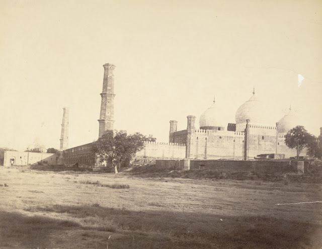
Photograph of the Chauburji Gateway at Lahore, Pakistan, taken by an unknown photographer in the 1880s, part of the Bellew Collection of Architectural Views. Lahore, the capital of Punjab province, is considered the cultural centre of Pakistan. Islam came here after the advent of Mahmud of Ghazni in 1021 AD, and it was subsequently ruled by a succession of dynasties of the Delhi Sultanate, followed by the Mughals, the Sikhs and the British. It reached its apogee under the Mughals, known as the Garden City and with enough architecture to rank it with other great Mughal centres like Delhi, Agra and Fatehpur Sikri. The Gateway of the Four Minarets or Chauburji was once the entrance to one of Lahore's many pleasure gardens. The garden, together with one of the gate's corner minarets (on the north-west) is now lost. An inscription on the gateway records that the garden was established here in 1646, in the reign of Shahjahan, by a lady described as Sahib-e-Zebinda Begum-e-Dauran, or 'the elegant lady of the age'. The lady referred to is probably Jahan Ara Begum, the eldest and favourite daughter of Shahjahan, who was known to have built gardens at Lahore. The gateway is beautifully decorated with rich mosaic-work.
Bridge in Murree
مری میں پل

Photograph of a bridge in Murree, now in Pakistan, taken by William Henry Baker in 1865, from the Macnabb collection. Murree is situated in the foothills of the Himalayas north-east of Islamabad in Pakistan. It was the summer residence of the local Government in the Punjab until 1876. There was a large military cantonment nearby, on the Grand Trunk road at Rawalpindi. The hill-station at Murree was established in 1851; it was the second largest hill-station in the area after the summer Presidency Capital at Simla. Murree was the site of one of four Lawrence Asylums set up by Lieutenant Colonel Sir Henry Montgomery Lawrence and Reverend William Parker to provide for the children of Officers and other serving soldiers. It is still in use as a private school today.
Clifton, Karachi [Bird Eye View]
کلفٹن ، کراچی

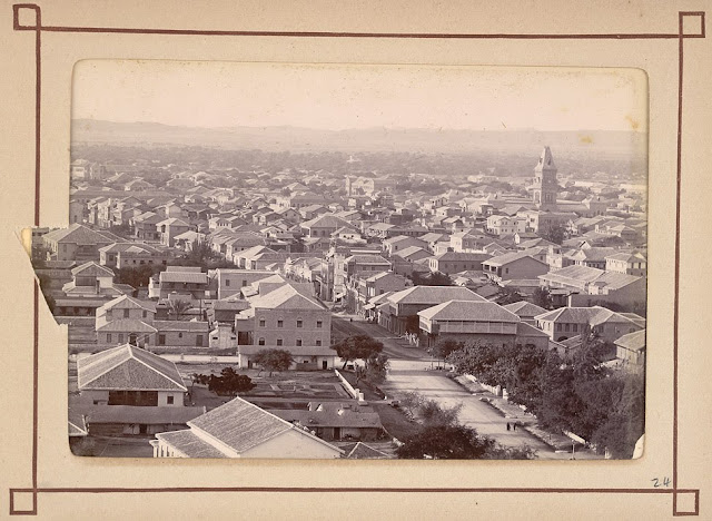
Photograph with a view looking along Clifton Road in Karachi, taken by an unknown photographer, c.1900, from an album of 46 prints titled 'Karachi Views'. Views 21-32 from this album join together to form a 360 degree panorama of the city from the tower of Trinity Church. Part of the Frere Hall can be seen at the extreme right. (Clifton is now one of the most exclusive residential areas of the city). Karachi, one of the world's largest metropolises, was once the capital of Pakistan. It is now the capital of the Sindh province in the lower Indus valley, and is the financial and commercial centre of Pakistan. This huge city was however developed only in the mid-19th century after the British conquest of Sindh. Karachi is built around a bay which is a natural harbour protected from storms by a group of small islands. Its history prior to the 18th century is sketchy but it is believed to be the ancient port of Krokala on the Arabian Sea, visited by Alexander's admirals in 326 BC. The small fishing village was known as Kolachi-jo-Goth in the 18th century, and then became a trading post under the Kalhoras and the Talpur rulers of Sindh, but the port remained small. With the British development of its harbour it grew into the large city of Karachi and an important centre of trade, particularly of cotton and wheat.
Victoria Road, Karachi [Bird Eye View]
وکٹوریہ روڈ ، کراچی

Photograph with a view of Karachi looking in a northerly direction along Victoria Road, with St Andrew's Church visible in the distance, taken by an unknown photographer, c.1900, from an album of 46 prints titled 'Karachi Views'. Views 21-32 from this album join together to form a 360 degree panorama of the city from the tower of Trinity Church. In the centre of the print is the single storey range of hospital buildings, with the Roman Catholic Church and Convent directly behind. Karachi, one of the world's largest metropolises, was once the capital of Pakistan. It is now the capital of the Sindh province in the lower Indus valley, and is the financial and commercial centre of Pakistan. This huge city was however developed only in the mid-19th century after the British conquest of Sindh. Karachi is built around a bay which is a natural harbour protected from storms by a group of small islands. Its history prior to the 18th century is sketchy but it is believed to be the ancient port of Krokala on the Arabian Sea, visited by Alexander's admirals in 326 BC. The small fishing village was known as Kolachi-jo-Goth in the 18th century, and became a trading post under the Kalhoras and the Talpur rulers of Sindh, but the port remained small. With the British development of its harbour it grew into a large city and an important centre of trade.
Suddar Bazaar, Karachi [Bird Eye View]
صدر بازار ، کراچی

Photograph with a view of Saddar Bazaar, Karachi, with the Empress Market in the right background, taken by an unknown photographer, c.1900, from an album of 46 prints titled 'Karachi Views'. Karachi, one of the world's largest metropolises, was once the capital of Pakistan. It is now the capital of the Sindh province in the lower Indus valley, and is the financial and commercial centre of Pakistan. This huge city was however developed only in the mid-19th century after the British conquest of Sindh. Karachi is built around a bay which is a natural harbour protected from storms by a group of small islands. Its history prior to the 18th century is sketchy but it is believed to be the ancient port of Krokala on the Arabian Sea, visited by Alexander's admirals in 326 BC. The small fishing village was known as Kolachi-jo-Goth in the 18th century, and then became a trading post under the Kalhoras and the Talpur rulers of Sindh, but the port remained small. With the British development of its harbour it grew into the large city of Karachi and an important centre of trade. Sadr Bazaars were permanent markets which existed all over the Indian sub-continent, they were developed by British forces in the towns they occupied to facilitate the provision of supplies to the troops in the cantonments. The Saddar Bazaar at Karachi followed a typical gridiron plan; all the major north-south streets of the Bazaar were laid out at right angles to Bunder Road, Frere, Somerset and Elphinstone Streets which along with Victoria Road, linked the northern part of the cantonment to the southern part. The area soon developed into the most fashionable part of the city, supplying the needs of both its civilian and military parts.
Napier Barrack, Karachi [Bird Eye View]
نےپیر بیرک ، کراچی

Photograph with a view looking north-east towards the Cantonments and Napier Barracks at Karachi, with Elphinstone and Frere Streets in the foreground, taken by an unknown photographer, c.1900, from an album of 46 prints titled 'Karachi Views'. Views 21-32 from this album join together to form a 360 degree panorama of the city from the tower of Trinity Church. The barracks were built by Charles Napier, the first governor of Sindh (1843-1847). It is constructed of the local buff Gizri stone. The main building faced the prevailing breeze and the deep arcaded verandahs and high ceilings were intended to make the interior as cool as possible. Karachi, one of the world's largest metropolises, was once the capital of Pakistan. It is now the capital of the Sindh province in the lower Indus valley, and is the financial and commercial centre of Pakistan. This huge city was however developed only in the mid-19th century after the British conquest of Sindh. Karachi is built around a bay which is a natural harbour protected from storms by a group of small islands. Its history prior to the 18th century is sketchy but it is believed to be the ancient port of Krokala on the Arabian Sea, visited by Alexander's admirals in 326 BC. The small fishing village was known as Kolachi-jo-Goth in the 18th century, and then became a trading post under the Kalhoras and the Talpur rulers of Sindh, but the port remained small. With the British development of its harbour it grew into the large city of Karachi and an important centre of trade, particularly of cotton and wheat.
General Hospital, Karachi [Bird Eye View]
جنرل ہسپتال ، کراچی

Photograph with a view looking north-east across Karachi taken by an unknown photographer, c.1900, from an album of 46 prints titled 'Karachi Views'. Views 21-32 from this album join together to form a 360 degree panorama of the city from the tower of Trinity Church. In the centre of this view is the single storey range of hospital buildings, with the Roman Catholic Church and Convent directly behind. Karachi, one of the world's largest metropolises, was once the capital of Pakistan. It is now the capital of the Sindh province in the lower Indus valley, and is the financial and commercial centre of Pakistan. This huge city was however developed only in the mid-19th century after the British conquest of Sindh. Karachi is built around a bay which is a natural harbour protected from storms by a group of small islands. Its history prior to the 18th century is sketchy but it is believed to be the ancient port of Krokala on the Arabian Sea, visited by Alexander's admirals in 326 BC. The small fishing village was known as Kolachi-jo-Goth and became a trading post under the Kalhoras and the Talpur rulers of Sindh in the 18th century, but the port remained small. With the British development of its harbour it grew into the large city of Karachi and an important centre of trade, particularly of cotton and wheat.
Clifton Road, Karachi [Bird Eye View]
کلفٹن روڈ ، کراچی

Photograph with a view looking south across the Clifton Road in Karachi, with Frere Hall at the extreme left, taken by an unknown photographer, c.1900, from an album of 46 prints titled 'Karachi Views'. Views 21-32 from this album join together to form a 360 degree panorama of the city from the tower of Trinity Church. Clifton is now an exclusive residential district of Karachi, one of the world's largest metropolises, once the capital of Pakistan. It is now the capital of the Sindh province in the lower Indus valley, and is the financial and commercial centre of Pakistan. This huge city was however developed only in the mid-19th century after the British conquest of Sindh. Karachi is built around a bay which is a natural harbour protected from storms by a group of small islands. Its history prior to the 18th century is sketchy but it is believed to be the ancient port of Krokala on the Arabian Sea, visited by Alexander's admirals in 326 BC. The small fishing village was known as Kolachi-jo-Goth in the 18th century, and then became a trading post under the Kalhoras and the Talpur rulers of Sindh, but the port remained small. With the British development of its harbour it grew into the large city of Karachi and an important centre of trade, particularly of cotton and wheat.
Government House, Karachi [Bird Eye View]
گورنمنٹ ہاؤس ، کراچی

Photograph with a view looking south-west in Karachi, with Government House in the foreground, taken by an unknown photographer, c.1900, from an album of 46 prints titled 'Karachi Views'. Views 21-32 from this album join together to form a 360 degree panorama of the city from the tower of Trinity Church. Karachi, one of the world's largest metropolises, was once the capital of Pakistan. It is now the capital of the Sindh province in the lower Indus valley, and is the financial and commercial centre of Pakistan. This huge city was however developed only in the mid-19th century after the British conquest of Sindh. Karachi is built around a bay which is a natural harbour protected from storms by a group of small islands. Its history prior to the 18th century is sketchy but it is believed to be the ancient port of Krokala on the Arabian Sea, visited by Alexander's admirals in 326 BC. The small fishing village was known as Kolachi-jo-Goth in the 18th century, and then became a trading post under the Kalhoras and the Talpur rulers of Sindh, but the port remained small. With the British development of its harbour it grew into the large city of Karachi and an important centre of trade, particularly of cotton and wheat. Government House was built in the 1840s by Charles Napier (1782-1853), British general and first governor of Sindh (1843-47). Originally, it was a single storey building, the upper storey being added by John Jacob in 1856-57. Set in 40 acres of gardens overgrown with oleanders and tamarisks, the house was approached along an impressive driveway which led from Victoria Road.
Artillery Lines, Karachi [Bird Eye View]
آرٹلری لائنز ، کراچی

Photograph with a view looking across the westernmost part of the Karachi cantonment, taken by an unknown photographer, c.1900, from an album of 46 prints titled 'Karachi Views'. Views 21-32 from this album join together to form a 360 degree panorama of the city from the tower of Trinity Church. Karachi, one of the world's largest metropolises, was once the capital of Pakistan. It is now the capital of the Sindh province in the lower Indus valley, and is the financial and commercial centre of Pakistan. This huge city was however developed only in the mid-19th century after the British conquest of Sindh. Karachi is built around a bay which is a natural harbour protected from storms by a group of small islands. Its history prior to the 18th century is sketchy but it is believed to be the ancient port of Krokala on the Arabian Sea, visited by Alexander's admirals in 326 BC. The small fishing village was known as Kolachi-jo-Goth and became a trading post under the Kalhoras and the Talpur rulers of Sindh in the 18th century, but the port remained small. With the British development of its harbour it grew into a large city and an important centre of trade and industry. The British established a cantonment here which was laid out separately to the 'Old Town' in a linear fashion. This area later became the basis of the 'New Town'.
A bit on the Ravi, Shahdara
دریائے راوی ، شاہدرہ

Photograph of a river view on the Ravi river near Shahdara, now in Pakistan, taken by an unknown photographer in the 1880s, part of the Bellew Collection of Architectural Views. The river of Northwestern India and northeastern Pakistan, and one of the 'five rivers' which give the Punjab its name, the Ravi rises in the Himalayas and flows westwards towards Pakistan. Shahdara lies on the right bank of the Ravi River opposite the city of Lahore. As a key halting spot after crossing the Ravi en route to Kabul and Kashmir, it was a place where the Mughals camped, it was also a recreation area close to Lahore. It was thus an important centre of the Mughal empire and they embellished it with magnificent gardens.
Side View of Badshahi Mosque, Lahore
بادشاہی مسجد ، ایک طرف ، لاہور

Photograph with a side view of the Badshahi Mosque, Lahore, Pakistan, taken by an unknown photographer in the 1870s, part of the Bellew Collection of Architectural Views. Lahore, the capital of Punjab province, is considered the cultural centre of Pakistan. Islam came here after the advent of Mahmud of Ghazni in 1021 AD, and it was subsequently ruled by a succession of dynasties of the Delhi Sultanate, followed by the Mughals, the Sikhs and the British. It reached its apogee under the Mughals, known as the Garden City and with enough architecture to rank it with other great Mughal centres like Delhi, Agra and Fatehpur Sikri. The Badshahi Mosque, one of the last great Mughal monuments, was built in 1673-74 by the Emperor Aurangzeb (ruled 1658-1707). Constructed of red sandstone and decorated with white marble, it was modelled on the Jama Masjid of Delhi, and departs from the local tradition of tile-facing. Set on a high plinth within a walled enclosure adjacent to the western wall of Lahore Fort, the mosque has three domes and an arcaded facade with octagonal minarets at the corners, and is said to be one of the biggest mosques in the world. Its interior is richly decorated with painted stucco.
Church and Bridge of Boats, Jhelum, Punjab.
چرچ اورناؤ کا پل جہلم ، پنجاب

This photograph, taken by William Baker in the 1870s, shows the River Jhelum in modern-day Pakistan. The Jhelum is the western-most of the 'five rivers' of the Punjab. Rising in the vale of Kashmir it flows south-west through the Punjab to the Chenab River. Bridges were constructed at strategic points along the river, initially of a semi-permanent nature, many were later replaced by more permanent structures of brick and lime mortar to cope with heavy water in the monsoon season. Three decades after this photograph was taken, the Lower Jhelum Canal was opened in 1901 and subsequently the Upper Jhelum Canal in 1915. These irrigate wide stretches of the Punjab in Pakistan today. Some boats and a church are also visible in the photograph.

Monday, July 26, 2010

Badshahi Mosque, Lahore
بادشاہی مسجد ، لاہور

Photograph of the Badshahi Mosque, Lahore, Pakistan, taken by an unknown photographer in the 1870s, part of the Bellew Collection of Architectural Views. Lahore, the capital of Punjab province, is considered the cultural centre of Pakistan. Islam came here after the advent of Mahmud of Ghazni in 1021 AD, and it was subsequently ruled by a succession of dynasties of the Delhi Sultanate, followed by the Mughals, the Sikhs and the British. It reached its apogee under the Mughals, known as the Garden City and with enough architecture to rank it with other great Mughal centres like Delhi, Agra and Fatehpur Sikri. The Badshahi Mosque, one of the last great Mughal monuments, was built in 1673-74 by the Emperor Aurangzeb (ruled 1658-1707). Constructed of red sandstone and decorated with white marble, it was modelled on the Jama Masjid of Delhi, and departs from the local tradition of tile-facing. Set on a high plinth within a walled enclosure adjacent to the western wall of Lahore Fort, the mosque has three domes and an arcaded facade with octagonal minarets at the corners, and is said to be one of the biggest mosques in the world. Its interior is richly decorated with painted stucco.
Gateway, Begumpura, Shalimar Rd, Lahore.
گیٹ وے ، بیگم پورہ ، شالیمار روڈ ، لاہور

Photograph of the Gulabi Bagh Gateway at Lahore, Pakistan, taken by an unknown photographer in the 1870s, part of the Bellew Collection of Architectural Views. Lahore, the capital of Punjab province, is considered the cultural centre of Pakistan. Islam came here after the advent of Mahmud of Ghazni in 1021 AD, and it was subsequently ruled by a succession of dynasties of the Delhi Sultanate, followed by the Mughals, the Sikhs and the British. It reached its apogee under the Mughals, known as the Garden City and with enough architecture to rank it with other great Mughal centres like Delhi, Agra and Fatehpur Sikri. Decorated profusely with intricate calligraphy and tilework, the Gulabhi Bagh Gateway was once the entrance to a garden which has disappeared. It was erected by Mirza Sultan Baig, a Persian noble, in the reign of Shahjahan (ruled 1628–58). The inscription over the archway gives the gate its title of Gulabi Bagh or Rose Garden and also records that it was built in 1655.
Entrance to the Badshahi Mosque
بادشاہی مسجد کا منظر

Photograph of the gateway of the Badshahi Mosque, Lahore, Pakistan, taken by an unknown photographer in the 1870s, part of the Bellew Collection of Architectural Views. Lahore, the capital of Punjab province, is considered the cultural centre of Pakistan. Islam came here after the advent of Mahmud of Ghazni in 1021 AD, and it was subsequently ruled by a succession of dynasties of the Delhi Sultanate, followed by the Mughals, the Sikhs and the British. It reached its apogee under the Mughals, known as the Garden City and with enough architecture to rank it with other great Mughal centres like Delhi, Agra and Fatehpur Sikri. The Badshahi Mosque, one of the last great Mughal monuments, was built in 1673-74 by the Emperor Aurangzeb (ruled 1658-1707). Constructed of red sandstone and decorated with white marble, it was modelled on the Jama Masjid of Delhi, and departs from the local tradition of tile-facing. Set on a high plinth within a walled enclosure adjacent to the western wall of Lahore Fort, the mosque has three domes and an arcaded facade with octagonal minarets at the corners, and is said to be one of the biggest mosques in the world. Its interior is richly decorated with painted stucco.
Minaret, Wazir Khan Mosque مینار ، وزیر خان مسجد

Photograph of an octagonal minaret topped by a cupola of the Mosque of Wazir Khan at Lahore, Pakistan, taken by an unknown photographer in the 1870s, part of the Bellew Collection of Architectural Views. Lahore, the capital of Punjab province, is considered the cultural centre of Pakistan. Islam came here after the advent of Mahmud of Ghazni in 1021 AD, and it was subsequently ruled by a succession of dynasties of the Delhi Sultanate, followed by the Mughals, the Sikhs and the British. It reached its apogee under the Mughals, known as the Garden City and with enough architecture to rank it with other great Mughal centres like Delhi, Agra and Fatehpur Sikri. One of the most famous of Lahore's mosques, this mosque was founded in 1634 by Hakim Ilmud Din Ansari, known as Nawab Wazir Khan, governor of the Punjab under Emperor Shahjahan (ruled 1628–58). It is beautifully decorated with floral and calligraphic patterns in glazed-tile mosaic work, thought to have been an innovation brought here from Thatta in the 16th century. It is in the decorative panels of this construction that the cypress first appears as a motif in mosaic work.
Wazir Khan Mosque Lahore وزیر خان مسجد لاہور
Photograph of Wazir Khan's Mosque at Lahore, Pakistan, taken by George Craddock in the 1880s, part of the Bellew Collection of Architectural Views. Lahore, the capital of Punjab province, is considered the cultural centre of Pakistan. Islam came here after the advent of Mahmud of Ghazni in 1021 AD, and it was subsequently ruled by a succession of dynasties of the Delhi Sultanate, followed by the Mughals, the Sikhs and the British. It reached its apogee under the Mughals, known as the Garden City and with enough architecture to rank it with other great Mughal centres like Delhi, Agra and Fatehpur Sikri. One of the most famous of Lahore's mosques, this mosque was founded in 1634 by Hakim Ilmud Din Ansari, known as Nawab Wazir Khan, governor of the Punjab under Emperor Shahjahan (ruled 1628–58). It is beautifully decorated with floral and calligraphic patterns in glazed-tile mosaic work, thought to have been an innovation brought here from Thatta in the 16th century. It is in the decorative panels of this construction that the cypress first appears as a motif in mosaic work.
Railway Station Lahore  ریلوے سٹیشن لاہور


Photograph of the Railway Station at Lahore, Pakistan, taken by George Craddock in the 1880s, part of the Bellew Collection of Architectural Views. Lahore, the capital of Punjab province, is considered the cultural centre of Pakistan. Islam came here after the advent of Mahmud of Ghazni in 1021 AD, and it was subsequently ruled by a succession of dynasties of the Delhi Sultanate, followed by the Mughals, the Sikhs and the British. It reached its apogee under the Mughals, known as the Garden City and with enough architecture to rank it with other great Mughal centres like Delhi, Agra and Fatehpur Sikri. The British took control of Lahore from the Sikhs in 1849, and transformed its landscape with railways, factories and roads. They continued the tradition of embellishing it with architecture, constructing some of the finer examples of colonial buildings in the Indo-Islamic-Gothic-Victorian style here.